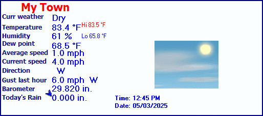
| The Fish Net Weather | |||
|---|---|---|---|
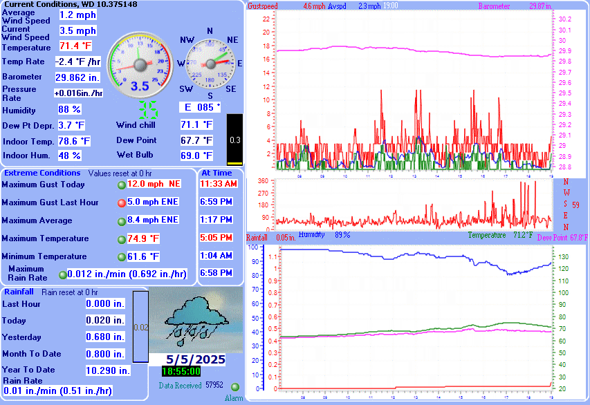
| LAST READING AT TIME: 4:45 PM DATE: July 26 2026, time of next update: 5:00 pm | |||
| Current Weather | Dry | Current Temperature | 83.5°F (28.6°C) (Heat Index 90.1°F ), Apparent temp 91.2°F |
| Maximum Temperature (since midnight) | 84.4°F at: 12:59 PM | Minimum Temperature (since midnight) | 65.7°F at: 4:14 AM |
| Average windspeed (ten minute) | 0.0 mph | Wind Direction (ten minute) | SSW (198°) |
| Heat Index | 90.1°F | Maximum Gust (last hour) | 4.0 mph at: 3:45 PM |
| Maximum Gust (since midnight) | 4.0 mph at: 10:58 AM | Maximum 1 minute average (since midnight) | 3.1 mph at: 11:15 AM |
| Rainfall (last hour) | 0.000 in. (0.0 mm) | Rainfall (since midnight) | 0.000 in. (0.0 mm) --- |
| Rainfall This month | 4.95 in. (125.7 mm) | Rainfall To date this year | 23.450 in. (595.6 mm) |
| Maximum rain per minute (last hour) | 0.000 in/min | Maximum rain per hour (last 6 hours) | 0.000 in/hour |
| Yesterdays rainfall | 0.250 in | DewPoint | 74.7°F (Wet Bulb :77.4°F ) |
| Humidity | 75 %, Humidex 103.3°F | Barometer corrected to msl | 29.799 in. (1009.1 hPa) |
| Pressure change | -0.01 in. (last hour) | Trend (last hour) | STEADY |
| Pressure change (last 12 hours) | -0.09 in | Pressure change (last 6 hours) | -0.09 in |